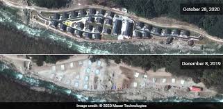
New Delhi: High resolution satellite imagery accessed by NDTV indicates that in addition to setting up a village more than two kilometres within Bhutanese territory on the eastern periphery of the contested Doklam plateau, China has built a road in the same area that stretches approximately 9 kilometres inside Bhutanese territory.
It is believed that this road could ultimately give the Chinese forces an alternate route to the Zompelri ridge, which the Indian Army had prevented Chinese forces from accessing in 2017 when the two sides faced off on the Doklam plateau.

On that occasion, Chinese construction workers had attempted to access the ridge by extending their existing track near the Indian Army's post at Doka La which lies on the boundary between Sikkim and Dokala.
Soldiers of the Indian Army had then physically blocked Chinese road construction workers on grounds that access to the Zompelri ridgeline (which lies further south) was unacceptable since it would allow Chinese forces a clear sight of the "Chicken's Neck", the vulnerable sliver of land that links the northeast of India with the rest of the country.

Now, three years later, Chinese construction workers, working on a different axis, have built a new road along the banks of the Torsa river, which extends southwards from the border between China and Bhutan.
This lies less than 10 km from the site of the 2017 face-off between Indian and Chinese forces which lasted more than two months and was only resolved when Prime Minister Narendra Modi and President Xi Xinping of China met in Wuhan in April 2018 where they agreed on de-escalating tensions.
"The Chinese have left untouched the 2017 stand-off site, which is located in one corner of Doklam,'' says strategic affairs expert, Dr Brahma Chellaney. ''But, step by step, they have been changing the status quo in the rest of Doklam, including by building permanent structures and roads and even setting up villages on a plateau that was uninhabited until three years ago.''
Clear evidence of Chinese road and village construction on the eastern periphery of the Doklam plateau emerged on Thursday when Shen Shiwei, a senior producer with CGTN, China's state-sponsored media, showcased several images of a village with several chalets by the side of a river.
He tweeted, ''Now, we have permanent residents living in the newly established Pangda village. It's along the valley, 35 km south to Yadong country. Here is a map to show the location.''

he new images shown in this report are from Maxar which provides some of the most comprehensive satellite imagery commercially available. According to Maxar, ''There has clearly been significant construction activity this year all along the Torsa River valley area with extensive road-building/construction activity underway as well as new military storage bunkers being built in China near the Doklam area".
The lead image in this report, contradicts a statement by the Bhutanese Ambassador to New Delhi, Major General Vetsop Namgyel.